The hiking trip by OGKL to Gunung Cantik is now rescheduled to 15 and 16 August. At that time, I am still in Kota Kinabalu. With that, I have to say that the plan to join them is off.
Have to think of what to do on the last week before going to Kota Kinabalu. There are various options to consider but they are all repeat trips!
Sunday, June 28, 2009
BROGA HILL

Jun 27, Sat, 4.30am
Left my house to head to Broga Hill that's located 37km from KL. It is only 30 minutes drive from KL and 3 km from Broga Hill.
How to go there. I was leaving from Putra Heights so naturally I'd take LDP heading to Kajang area. Drive down towards Semenyih. You'll not get lost following the signboards on the highway. As you exit from the highway towards Semenyih, you'll see a big signboard to University of Nottingham, Malaysia campus. On your right side, there's a Petronas station. Take the exit to the left to Broga town and you'll pass the campus on your left. Two kilometers from there, you'd reach the parking area at the foothill of Broga Hill. It's located in a palm oil plantation right across a Rabbit Farm. You can park your car on the roadside or like most people, they parked their car in the Palm oil estate itself.
6.20am
We started the hiking. It was still dark and I put on headlight (just bought it for RM40 from ACE Hardware, a few days before!). I didn't really know the way and I realised that we took the wrong trek and people behind us turned to the right and went up the hill. Instead of doing that, we went straight. We turned back and tailed the two groups. We climbed for 40 minutes to reach the top! It was an easy hiking, not much challenge at all, just what I needed after hiking Gunung Angsi and Ulu Semangkuk in the same month. It was more like a walk in the park!

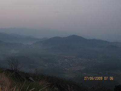
7.00am
We reached the top of the hill. It's a very popular spot especially dueing weekends. Easily, there are 200 people on the hill. There could be human traffic jam up there! We stopped over to take pictures amongst the crowds at the first two peaks.
Below are the pictures of the famous X trail of Broga Hill!


No tall trees on the hill, that explains why people go up early to avoid the sunlight! In fact it's full of lalang. It's more like lalang hill! At first I thought people go up early to see sunrise. When you see the sun, it was already like 7.30am something. That's not a sunrise anymore! It's advisable anyway, to go up early to avoid the scorching sunlight. By 10am, it's so hot. I don't think there'd be that many people on the hill at that time.

The lalangs were partly torched. It must be a fire started by smoker who simply threw away his cigarette butt in the dry lalang. (my assumption only lah!). There were patches of burnt lalang here and there. There were a few tall trees on this hill and they were not spared by the fire.
The highest peak is located at the far end, next to a jungle. There are some people who go into the jungle, trek it and come out from the other side of the hill. I didn't do that as my car was parked on this side of the foothill.
9.00am
We started descending after taking so many pictures (typical of us!!, one pic in every 10 steps!!). Going down is easy and some people just slided down. As for me, I prefer to run when there were not that many people along the stretch. We ran down the hill and reached the foothill 20 minutes later.

11.00am
Stopped over in Kajang and had satay. Haven't been to this place for so long and it has changed a lot. The interior is so much different and better now.
As a summary, to those who want to start a hiking activity, Broga Hill would be a good choice. It was steep at the beginning otherwise, not much challenges at all. I am planning to take my whole family there one of these days!
Wednesday, June 24, 2009
GUNUNG CANTIK
I googled Gunung Cantik and much to my surprise, I didn't see that many write-ups about this mountain. It's located in Cameron Highlands, 1802m above sea level. That's much I know from the results of my google. And from Gunung Cantik, one can also go to Gunung Cantuk (Cantik and Cantuk? Sounds like a joke!), 1806m. One can see BOH tea plantation from the peak of both mountains!
Anyway, I am still waiting for the confirmed plan of OGKL (Orang Gunung Kuala Lumpur) as I read that they are planning to go there on Aug 8. It's a few days before my Mt. Kinabalu trip. May be I should consider seriously about joining them. I could just take the opportunity to buy fruits and vegetables in Cameron. Hmmm! That's not a bad idea!
Anyway, I am still waiting for the confirmed plan of OGKL (Orang Gunung Kuala Lumpur) as I read that they are planning to go there on Aug 8. It's a few days before my Mt. Kinabalu trip. May be I should consider seriously about joining them. I could just take the opportunity to buy fruits and vegetables in Cameron. Hmmm! That's not a bad idea!
Monday, June 22, 2009
GUNUNG GAP & ULU SEMANGKUK
 It's the first time, I joined a hiking group in their hiking activity and I was following them to Gunung Gap & Ulu Semangkuk. The hiking itself took around 4 hours return climbing. However, their planning included camping at Kelah Sancturay at Pretak. There were 15 of us.
 We left KL at 9pm, an hour late from the original plan of 8pm. It's because of one person, we had to wait for an hour. That's typical when you're in a group.
The camping place is around 73km from KL. It's midway from Kuala Kubu Bharu (KKB) to Bukit Fraser. We reached there past midnight. In the middle of the night, we went up the hill across the road to the camp site, going through a small path in the jungle. When we went back to the car the next morning, we realised we took a wrong way (more difficult!), in fact there was a gravel road connecting the main road and the campsite.
After putting up the tent, I didn't lose any chance, I slept straight away, without taking bath. What to do, it's way past midnight and my sleeping time, I was tired! And after sleeping for about half hour, my tent mates came back and joined me in the tent. From then on, I couldn't sleep at all until morning.
After suboh prayers (there is surau and toilet in the sanctuary area), I was hungry and started nibbling some snacks while the others were still snoring!!
A little bit info on Santuari Kelah Sg. Chiling, it was established in 2006 (it's still new!) as a sanctuary for a fish species called Kelah. That species was almost extinct when they started gazetting the area as sanctuary. Since then, the kelah population has grown again. Nobody is allowed to fish in which ever way in the sanctuary area. You'd be fined for RM10,000! There's waterfall within the sanctuary area. The group stayed another night to go there!

After a proper breakfast in KKB town, we went straight ahead to the starting point of the hiking trip. It was 10.55am when we started ascending. The starting point is located near Gap Rest house.
The first 10 minutes of climbing, we went through bamboo jungle! And a hiking friend, who did a knee surgery 4 months ago, had to quit and returned to the base! After going through the bamboo jungle, the surroundings looked familiar with vertical slopes in tropical rain forest. It took almost one hour to reach the first peak, Gunung Gap! The summit indicator was gone! We took a break for about 40 minutes while waiting for the rest of the group.

From there we continued our journey for the second peak. There were two treks from Gunung Gap and we took the one on the left. Just like the treks to Gap, the treks to Gunung Ulu Semangkuk are steep too with occasional flat areas! Midway through, the weather was cooler and it was so refreshing! It feels like we were at Fraser's Hill itself! And it rained too!
We kept our electronic devices, camera and handphone in plastic bags and continued in the rain until we reached the peak of Ulu Semangkuk. The rain added the beauty of the area as it became very misty and looked mysterious, like those scenes from Lord of The Rings! We took almost 2 hours to reach the peak!

They cooked instant noodle for lunch. And the noodle was the cause of my stomach upset later on! We stayed there until almost 3pm. The rain stopped minutes before we started descending. Due to to the rain, we didn't have that many photos taken at the peak! Talking about the peak, nothing much to see as it was surrounded by tall trees!
On the way down, passing Gunung Gap, my stomach upset started kicking in and I really had to rush down as I didn't want to do my 'big business' in the jungle! In just 1.5 hours we reached back the starting point. As for me, I went straight to the nearby toilet!
To make the story short (dah banyak sangat bercerita!), after taking medicines, I left for the camp site and waited for more than 1 hour for the rest to come back. Had to leave the group as I had promised my family I'd be home on Saturday night itself. I reached home sweet home around 11pm.
All in all, it was my first experience joining a big group and I enjoyed it. Had to be flexible with my timing and had to take some of the lawak bodoh of the group too! I guess, if it's for hiking trip, would not join them again. I reserve my comments!!
Sunday, June 14, 2009
BUKIT TABUR - EAST SIDE
The east side of Bukit Tabur is just as interesting. I knew about the treks from fellow trekkers that I met after completing the climb of the more popular west side.
The fun began immediately after we crossed the streams. We thought of bathing in the streams after the climb but the place was dirty and smelly and the water was not deep enough either.
The treks are more challenging than the west side. It's not as rocky but we had to do a lot of rock climbing.

The first hurdle was going through the steep slope with rope. It was fun but we had to make sure that the rope was still in good condition. Otherwise, if it snaps half way,there you go! The slope below was neither steep nor high. We could still climb up without the rope (I think so!!).
 We had fun and this place is recommended to those who want to get away from the city on weekend. We spent 4 hours to complete the climb.
The treks are located behind Ulu Klang Gate dam. We need to cross small streams to get to the treks.
The fun began immediately after we crossed the streams. We thought of bathing in the streams after the climb but the place was dirty and smelly and the water was not deep enough either.
The treks are more challenging than the west side. It's not as rocky but we had to do a lot of rock climbing.
The first hurdle was going through the steep slope with rope. It was fun but we had to make sure that the rope was still in good condition. Otherwise, if it snaps half way,there you go! The slope below was neither steep nor high. We could still climb up without the rope (I think so!!).
We can see the dam clearly from from the east side hills.You can't see it from the west side though. The lake is closer to this side of the hill.
The slope below is 50 meters high and it's almost 90 degrees. It could be dangerous and we have to be very careful. And the this slope is the reason for me not to promote this place to my female colleagues. I don't want to be responsible for their safety And at the same time, I don't want to end up spending so much time looking after them. Sorry!!! And we had to use the rope. However, we were advised not to depend so much on the rope! Thanks to a group of trekkers, otherwise we would have stopped at Peak 5.
We had fun and this place is recommended to those who want to get away from the city on weekend. We spent 4 hours to complete the climb. We were told that people would go up at around 6am, early enough to reach the peak to catch the sunrise. I am planing to do that one of these days. Perhaps, I'd take my son along.
GUNUNG LEDANG
I just received an email from the organiser saying that Gunung Ledang is closed to public on Jul 4, due to Government's function?? Therefore, our trip there is now postponed to Jul 11 instead.
Well, with this news, I need to juggle up my hiking schedules. It looks like it, I am going to Gunung Datuk again on Jul 4 instead.
On Jun 27, a lot of fellow trekkers are busy with KL Marathon. I didn't sign up as I was scheduled to go to Gunung Belumut. However, that trip is also off. Now, I am planning to go to Broga Hill instead. It's a very mild hiking trip, as what I was told!
And I have to ask around on how to go there. It's located in Semenyih! That's all I know! Have to google map it as well!
Saturday, June 13, 2009
GUNUNG BELUMUT IS STILL CLOSED TO PUBLIC
I was very excited when I got sms from Bang Yem giving the details of Address, Phone and Fax Nos of Jabatan Perhutanan Johor Tengah.
I faxed my letter for the permit a few days after that and followed up by calling them up the next day.
The person who picked up the call told me that the park is still closed to public even for hiking. The construction works at the foothill are still not completed.
They will make the announcement soon when the park is open again.
There it goes, my plan to climb Gunung Belumut on Jun 27 this month!
Thinking about Plan B now! There is KL Marathon on May 27, unfortunately, I didn't sign up as I thought my hiking trip is ON!!
Sunday, June 7, 2009
GUNUNG ANGSI
 Gunung Angsi (825 meter above sea level) is located in Hutan Lipur Ulu Bendol, 10km from Seremban town.
You need to pay RM5.00 fee at the office before you can start your climbing. The ranger there, En. Roslan Malek (013-3749933) is very friendly. After paying the fee, he explained the trail, where to begin, what to expect and how long it takes to reach the summit.
 From KL, take Seremban - KL highway and exit at Senawang Interchange. Drive towards Kuala Pilah, the road is winding. You will not miss the big signboard, Hutan Lipur Ulu Bendol. The park is on your right. It's a very popular spot amongst the locals for camping. Sad to say, since there are so many umat there, the palce is dirty place, at the camping area, along the treks and at the summit too!
 We started hiking at 8.27am and despite the briefing from En. Roslan, we were lost, heading towards the main road instead. We wasted about 15 mins to get back to the right trail.
Once we found the right trail, there was no turning back. We walked leisurely along the streams and making stops (as usual, taking pictures).

There were slopes here and there but not steep at all. We hiked until we reached Jeram Kak Lang. Here we had to cross the streams. Be careful, not to get your shoes wet! It's a long way to go.
From here, we got out to a clear area, suddenly it was so bright. It was like 10 meters in distance and we got into the forest again. We had to cross the stream again and from the signboard, it was stated as Phase 3A. Here, it's the start of the real climb. The slopes were very steep. We had to make a few pit stop to rehydrate.
From here, we got out to a clear area, suddenly it was so bright. It was like 10 meters in distance and we got into the forest again. We had to cross the stream again and from the signboard, it was stated as Phase 3A. Here, it's the start of the real climb. The slopes were very steep. We had to make a few pit stop to rehydrate.
The best part, the biggest challenge to some was at Phase 4A. We had to climb using ropes and of course had to dirty our clothes. It was fun and we met a family (with children as young as 5 years old) descending from the same spot. From here, it'd take between 30 - 45 minutes to reach the top.

We reached the peak at around 11;45am, approximately 3.5 hours of climbing. Not bad at all! From some blogs that I read, it'd normally take 4 hours. It took us another 2 hours to descend. Of course, don't expect much on the views from the peak. It's all blocked by the trees. One one side, you'd see Seremban town.

On the way back, we stopped for lunch at Agro Park, a Chinese Muslim restaurant and I did my Zohor prayers there, it was around 3.45pm then.

We enjoyed the trip. A 6 hours of hiking is what I need for Mt. Kinabalu!!
Friday, June 5, 2009
FESTIVAL OF MAGIC
It's mid-term school holiday!
Normally, I'd take the family for a short local holiday, PD or Genting! This time around, I didn't plan anything at all. I guess, I was busy planning for my own hiking trips.
So, when my eldest son told me that he'd like to spend the whole day at Subang Parade to see magic show competitions, I'd have no choice but to say yes! Left him there with pocket money while I took the time to go to KL to do my banking activities.
So, he stayed there until 6.00pm and decided to give it a miss to some other competitions after that. He said he's tired already, tired of walking. Most importantly, he enjoyed his time and bought himself some magician's goodies as well.
Normally, I'd take the family for a short local holiday, PD or Genting! This time around, I didn't plan anything at all. I guess, I was busy planning for my own hiking trips.
So, when my eldest son told me that he'd like to spend the whole day at Subang Parade to see magic show competitions, I'd have no choice but to say yes! Left him there with pocket money while I took the time to go to KL to do my banking activities.

So, he stayed there until 6.00pm and decided to give it a miss to some other competitions after that. He said he's tired already, tired of walking. Most importantly, he enjoyed his time and bought himself some magician's goodies as well.

Wednesday, June 3, 2009
THIS IS EVEN MORE SERIOUS!
Yup!
This is even more serious. Recently, I ordered hiking stick online, where else, amazon.com! It costs USD12.99 without shipping charge.
I need the hiking stick for my hiking trip as my knees are rather weak! Due to the high impact of treadmill exercise over the years, I got problem with my knees. Age is another factor!! I got no problem going up a steep slope. However, coming down is another story! Aduh Mak! Sakitnya lutut aku!!
I really hope that the hiking stick will help to cushion off the impact of going down the slopes on my knees!

Tuesday, June 2, 2009
GUNUNG BELUMUT
I woke up this morning feeling good. I saw the sms signal of my HP blinking, that means there are messages waiting for me!
Turned out, it's a message from Abang Yem giving the address of Jabatan Hutan Daerah Johor Tengah. As I mentioned, hiking permit is required to climb up Gunung Belumut.
The address is:
Pejabat Hutan Daerah Johor Tengah
Jalan Pejabat Kerajaan
86000 Kluang
Johor
Tel: 07-7725944
Fax: 07-7720844
I will fax the letter today. And I guessed the basic information is required, Name, NRIC, Gender, Contact Number and Address.
Subscribe to:
Posts (Atom)
